Raspberry Pi GPS Time Server with Bullseye

I’m into accurate time. Ever since I stumbled across the SatSignal.eu site I have been running a Raspberry Pi on my network as a Stratum 1 time server. For those not familiar with the stratum, the only level higher is Stratum 0 and that is reserved for the absolute standard of time sources like the National Institute of Technology clock and GPS Satellites.

2016 Raspberry Pi Clock showing leap second addition at the end of 2016

I had been having some entropy on my current set of 6 GPS clocks from various issues, so I decided to rebuild my clock from the base install of the new Raspbian Bullseye distribution. Since I didn’t see a single definitive source, I put this listing together and I’m glad to share it with the community because it has been good to me with previous builds. My sources include SatSignal.eu, tomasgreno.cz, and adafruit.com. Much of what I did is just compiling and changing the order of some steps slightly to minimize reboots. Those others may work better for you, but this version worked for me.

Let’s talk hardware. I have done this project with a Raspberry Pi 1 through a Pi 4 as well as the Pi Zero and Zero W. I prefer the form factor of the full sized Pi to go along with the GPS hardware, but as long as you can make the GPIO connections from the GPS to the Pi all should work.

For a GPS module I use the Adafruit Ultimate GPS with the following pin connections. If you want to use something different, consult the breakout manufacturer and use pinout.xyz to set the proper connections. For my connections I typically use:

GPS Breakout PinRaspberry Pi Pin
VIN (Voltage in)Pin 4 – 5V Power
GND (Ground)Pin 6 – Ground
RX (Receive, to get data from the Pi TX)Pin 8 – GPIO 14 – UART TX
TX (Transmit, to send data to the Pi RX)Pin 10 – GPIO 16 – UART RX
PPS (Pulse Per Second)Pin 12 – GPIO 18

It’s not a typo, make sure TX goes to RX on the other board and vice versa.

Now on to software. Start with a clean version of Raspbian Bullseye on an MicroSD. I downloaded mine from the official RaspberryPi .com website. I used the “Raspberry Pi OS with Desktop” version and used an 8 GB MicroSD card as the media. I’m skipping the items related to base configuration of the host name and other start-up items, there are other sources for that. All the commands you see will be via the command prompt.

The instructions from here forward assume you have a working Raspberry Pi, connected to the internet with the GPS attached.

  • Start by adding two additional lines to the /boot/config.txt file. This starts the process to disable Bluetooth on the Pi and sets the Pulse Per Second GPIO Pin if your GPS supports it.
    • Note in this document, the command following $ gets entered at the command prompt, other commands are entered inside the file, at the bottom on a new line is usually good. Once commands are entered, use Ctrl-X, Y and Enter to save and exit the file and return to the command prompt. And yes, I use NANO as my text editor. You should use what you want. I’m not a text editor drill sergeant.
$ sudo nano /boot/config.txt

#Changes for GPS Clock
dtoverlay=pi3-miniuart-bt
dtoverlay=pps-gpio,gpiopin=18 (Customize to appropriate pin)
  • Disable Bluetooth in system control
$ sudo systemctl disable hciuart
  • Add a reference to /etc/modules to software for PPS management we will install shortly.
$ sudo nano /etc/modules

pps-gpio
  • Run a complete set of updates to the Pi Software
$ sudo apt-get update
$ sudo apt-get dist-upgrade
$ sudo rpi-update
$ sudo reboot

Once the computer has rebooted, it’s time to begin installing the key software.

  • Install PPS tools and a set of system libraries
$ sudo apt-get install pps-tools
$ sudo apt-get install libcap-dev
$ sudo reboot
  • Now let’s test to see if the PPS software was installed by checking some OS boot logs
$ lsmod | grep pps 

You should get two responses back that look something like this. Don’t worry if the numbers are different.
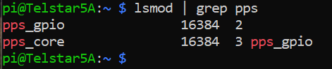
$ dmesg | grep pps

Make sure you have a line that says “new PPS source…”

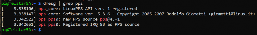
  • Once you see both of those, we can check and see if the GPS is sending data. Your GPS must have a “fix” which means it’s getting data from at least three satellites in order for this to work.
$ sudo ppstest /dev/pps0

Success looks like this:

Don’t worry about the specific numbers, just look for incrementing sequence numbers. The data will continue to populate every second until you hit CTRL-C to stop it.

  • Moving on, we have installed the GPS module and gotten data from part of it, but have not installed the main GPS software set yet. This should do it:
$ sudo apt-get install gpsd gpsd-clients gpsd-tools 

Once those are complete we can take a look at the data coming from the GPS by peeking at the port.

$ sudo cat /dev/ttyAMA0

You should get a continuing output with lines like this. I look for lines that start with $GPRMC (Specific location obscured by X’s)

pi@Telstar5A:~ $ sudo cat /dev/ttyAMA0
$GPGGA,220752.000,33XX.XXXX6,N,084XX.XXXX,W,1,07,1.13,278.6,M,-30.9,M,,*5E
$GPGSA,A,3,04,03,26,31,22,27,16,,,,,,1.46,1.13,0.92*0A
$GPRMC,220752.000,A,33XX.XXXX,N,084XX.XXXX,W,0.27,216.85,171121,,,A*7C
$GPZDA,220752.000,17,11,2021,,*51

Again, CTRL-C to stop it. If you get a stream of data and it’s gibberish your GPS may be sending at a different rate. A good place to start if you see that is this SatSignal.eu page which looks at other GPS modules and other methods.

  • Now, let’s temporarily send that data to some GPS software for interpretation.
$ sudo gpsd /dev/ttyAMA0 -n -F /var/run/gpsd.sock

Then we’ll open the GPSMON software to look. (There’s also a tool called CGPS. Use either, this is a personal preference thing)

$ gpsmon
Location obscured for privacy.

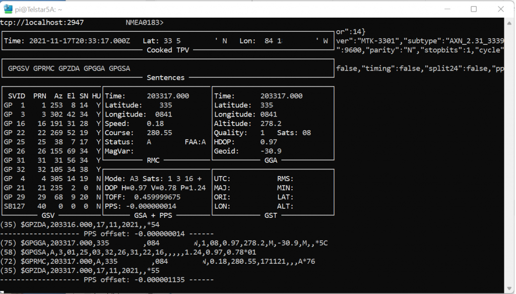
The screenshot above will tell you your exact position, the number of satellites your GPS sees, and the status of your PPS data all in one screen. Did I mention you CTRL-C to get out of a screen like this? Because you do.

  • Configure the GPS software to auto-start when you boot your machine. I have seen a couple of different processes, but this one works consistently for me.
$ sudo nano /etc/default/gpsd

Unlike the other file edits where you add a line, this is what the whole file should look like when you are done. You may just want to cut and paste this whole section, or type it in, whatever works for you, I won’t judge.

#Updated for GPS Pi Clock

START_DAEMON="true"

# Devices gpsd should collect to at boot time.

GPSD_SOCKET="/var/run/gpsd.sock"

# They need to be read/writeable, either by user gpsd or the group dialout.
DEVICES="/dev/ttyAMA0"

# Other options you want to pass to gpsd
GPSD_OPTIONS="-n"
GPSD_SOCKET="/var/run/gpsd.sock"

# Automatically hot add/remove USB GPS devices via gpsdctl
USBAUTO="false"
  • Almost done with the GPS section. Four more commands to go.
$ sudo systemctl stop gpsd.socket
$ sudo systemctl disable gpsd.socket
$ sudo ln -s /lib/systemd/system/gpsd.service /etc/systemd/system/multi-user.target.wants/
$ sudo reboot

That third $ command (between “disable” and “reboot” goes on a single line, this blog text tool wraps it. It should look like this:

  • If you want to reconfirm everything is working again after reboot, run GPSMON like above and look at the pretty data fly by. Now let’s connect the GPS to the clock. I’m choosing to use NTP as my time server software for this project. You might want to play with Chrony as well.
$ sudo apt-get install ntp

Once that is done, you want to stop the timesyncd service that is installed by default with Bullseye and replace it with NTP.

$ sudo systemctl stop systemd-timesyncd
$ sudo systemctl disable systemd-timesyncd
$ sudo service ntp stop
$ sudo service ntp startntp q -

Let’s test. “Out of the box” the NTP software checks with servers on the internet to get the time. It will look something like this:

$ ntpq -p -c rl
The * on the left indicates the chosen server, this one is at Georgia Tech.

Great news! Clock is syncing, but if you look at the bottom you’ll see after “leap=00” it says “stratum=2” which is nice, but we want to use the GPS to make it a Stratum 1 clock.

  • It’s time to cross the streams and point the NTP software to look at the GPS and PPS signals for time. That means editing the NTP configuration file.
$ sudo nano /etc/ntp.conf

There are a lot of other settings in the file, so I won’t give the whole file this time but here’s what I recommend. Scroll down until you get to this section:

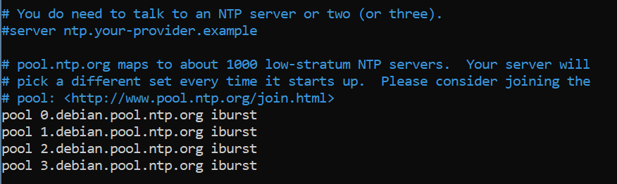
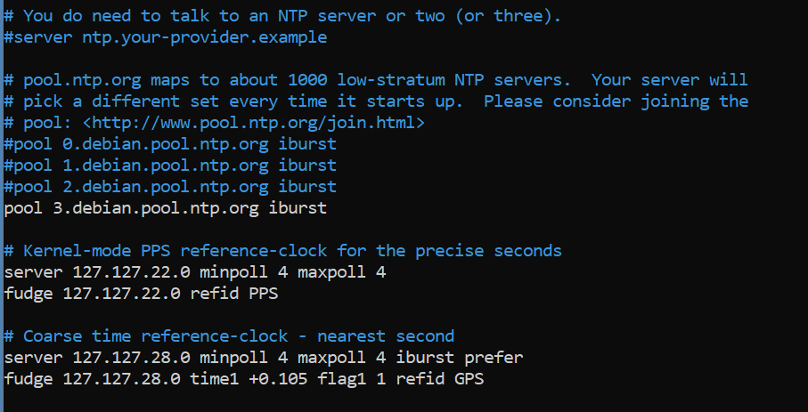
Use the # sign as the beginning of a line to comment out several of those “debian.pool” lines. You do want to keep an internet server on the list as a backup and for diversity, but you won’t need all of them. Save that for the folks that don’t have satellite time at home. Just below the “pool” entries, add each of the 6 lines on a new line:

# Kernel-mode PPS reference-clock for the precise seconds
server 127.127.22.0 minpoll 4 maxpoll 4
fudge 127.127.22.0 refid PPS

# Coarse time reference-clock - nearest second
server 127.127.28.0 minpoll 4 maxpoll 4 iburst prefer
fudge 127.127.28.0 time1 +0.105 flag1 1 refid GPS

If you want to use different servers on the internet, there are plenty to supplement. The manual page about ntp.conf can tell you more about other things you can do with this file.

When your changes are made it should look like this.

Do that cool CTRL-X thing and get out of there before you break anything (kidding).

Time to get the NTP client to read the new configuration file.

$ sudo service ntp restart

It sometimes helps to reboot too. Your call.
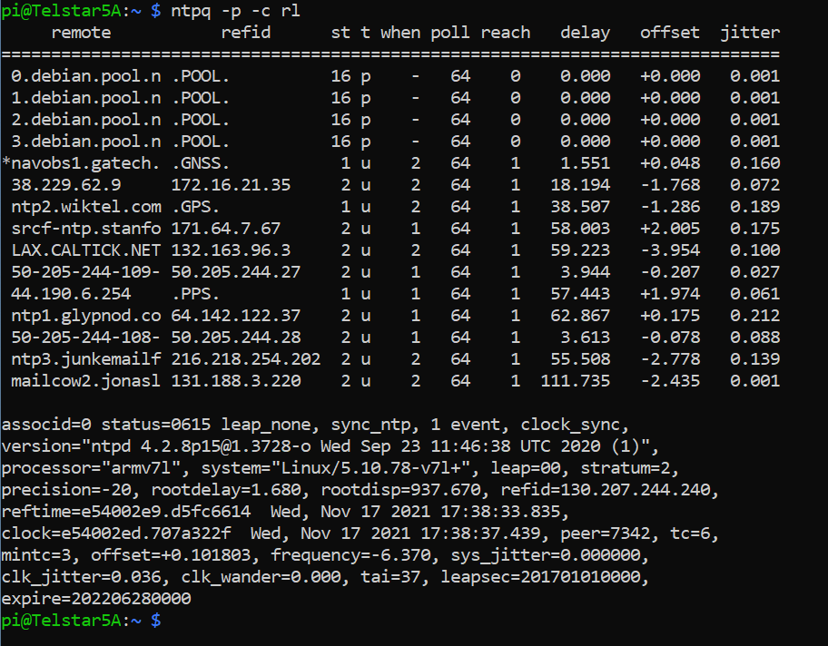
Now let’s check and see what time source we are using:

$ ntpq -p -c rl

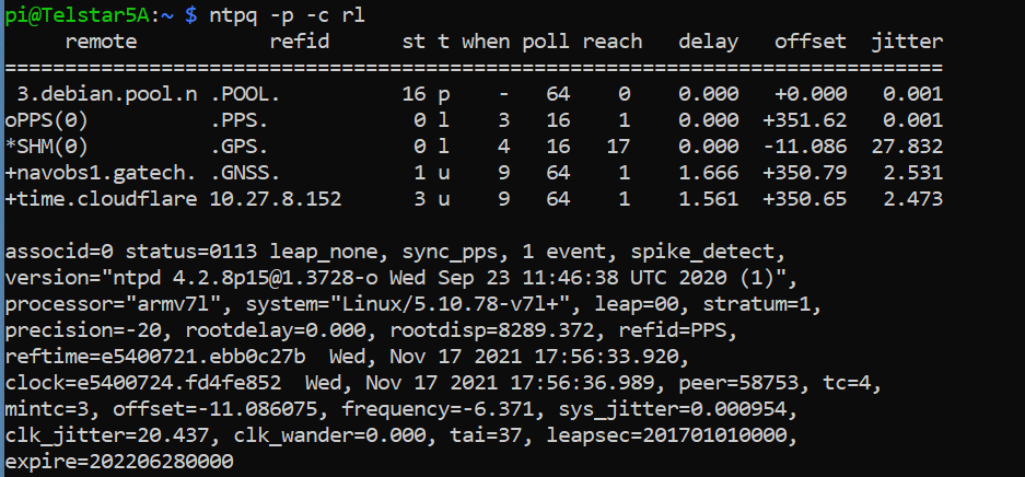
Success! Why? Three things you want to see on this screen:
1 – The SHM / .GPS. line has a * next to it, indicating it’s the primary time source. In the “st” column you can see a 0 which indicates it’s connected to a “Stratum 0” source.
2 – The PPS / .PPS. line has an o next to it, indicating it is a “PPS peer” and it’s getting very specific pulse data from the GPS signal. It’s also a “Stratum 0” source.
3 – The “stratum” field for your NTP server now is “stratum=1” which is pretty much the best you can get as a home user.

It may take a little bit for the PPS to settle in as the primary time source, so don’t worry if it doesn’t do it in the first 5 minutes.


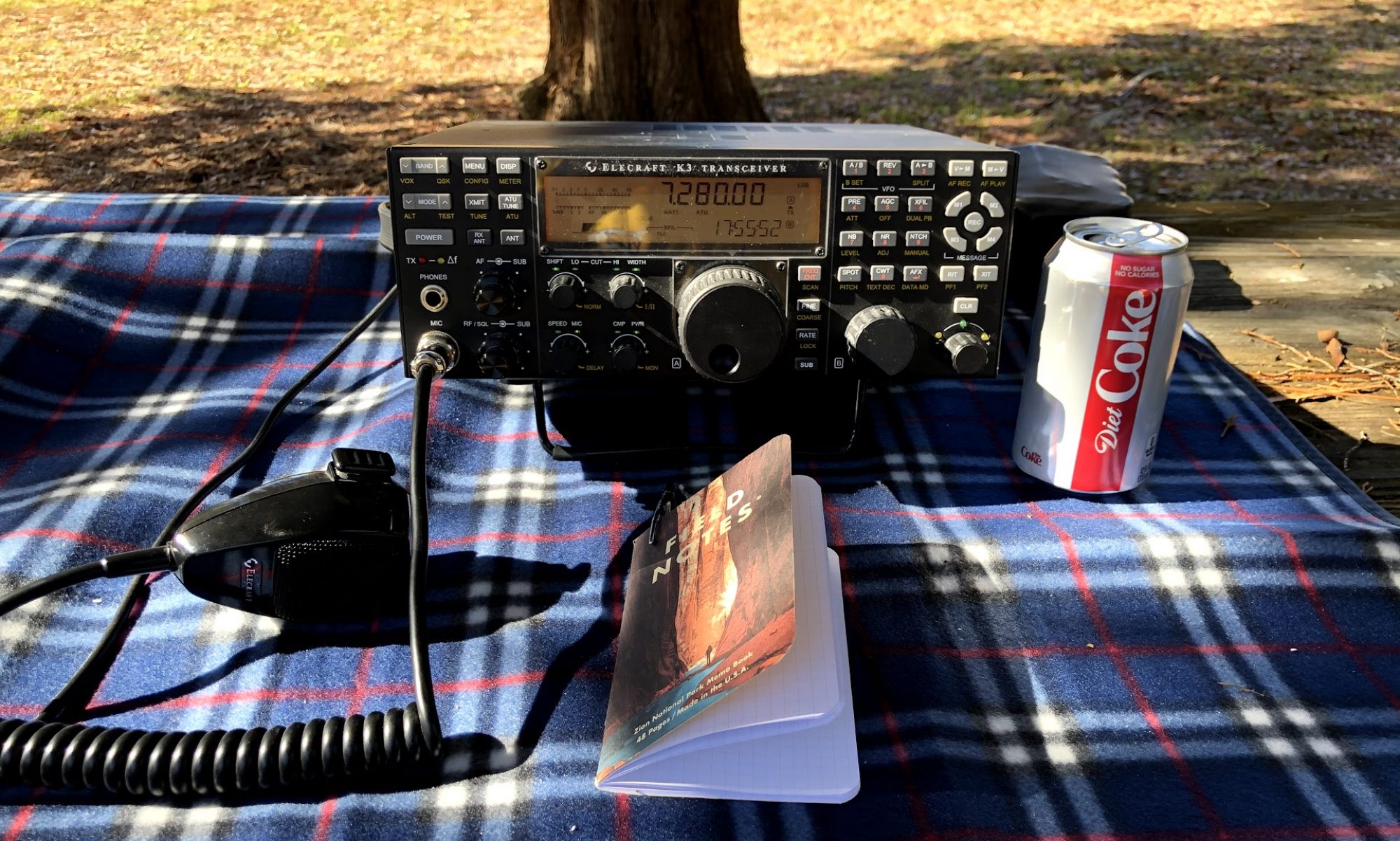
So, that’s the project. Why do you need this? Well, I do it for fun, but there are several applications that require very accurate time. For instance in Ham Radio the cycles for a program like FT8 depend on an accurate clock to switch between receive and send modes. Is this the thing I’m going to replace a Rubidium time standard with? No, but for about $100 bucks it’s a nice thing to have an a good early project for someone learning about Raspberry Pi. You can set Windows, Mac or Linux clients to point to your home server for time instead of time.windows.com or other sources.

One final note, this is accurate for me as of the time in that last screen shot. Something is bound to change eventually, so expect these instructions to drift over time as things change. Figuring that out is one of the fun things for me.

If you do this project and want to share success, you can tweet me @N4BFR or find me in other place on the internet.

Raspberry Pi – Buster to Bullseye Upgrade in Place Bug

I started upgrading one of my Raspberry Pi from Buster to Bullseye by using the APT tool and following along with the TomsHardware Guide. After completing Step 6 by changing the repository name, I ran

$ sudo apt dist-upgrade

It ran a couple of items then this advisory appeared.

Some packages could not be installed. This may mean that you have
requested an impossible situation or if you are using the unstable

distribution that some required packages have not yet been created

or been moved out of Incoming.

The following information may help to resolve the situation:


The following packages have unmet dependencies:

libc6-dev : Breaks: libgcc-8-dev (< 8.4.0-2~) but 8.3.0-6+rpi1 is to be installed

I had not run into that before, but thankfully, way down below the article and about 42 different ads I found the comment section. In that, a user name TJ Hooker had my answer:

I worked around that by executing sudo apt install gcc-8-base, then running dist-upgrade again.

So I gave it a try and sure enough, the upgrade was underway. Here are the two commands:

$ sudo apt install gcc-8-base 
$ sudo apt dist-upgrade

Pick back up at step 9 and 10 after that, which are:

$ sudo apt autoclean
$ sudo reboot

Then you are done. Hope this blog post makes it a bit easier to find if someone else encounters this.

P.S. – All in all I’m not sure if it wouldn’t have been faster to burn a new Bullseye card and port my content, but that’s no fun, is it? For additional reference here is the full set of commands because I am sure I will be doing this again on other machines, now I can find it.

$ sudo apt update
$ sudo apt dist-upgrade -y
$ sudo rpi-update  
    [Reboot when complete]
$ sudo nano /etc/apt/sources.list  
    [Change buster reference to bullseye]
$ sudo apt update 
     [Now gets Bullseye updates]
$ sudo apt dist-upgrade
      [if error, then run command below then rerun dist-upgrade]
    $ sudo apt install gcc-8-base 
$ sudo apt autoclean
$ sudo apt reboot

Celebrating Halloween with the Giz Wiz

I joined in to a live stream last weekend with Mad’s Maddest Writer, Dick DeBartolo, the GizWiz. We had some great chat fun and I shared my Halloween Video.

The group had a virtual scavenger hunt and I WON! Here’s the point in the video where I grabbed the winning item. Thanks to Mr. DeBartolo for sending me a signed copy of MAD Magazine and a signed Alfred E. Newman picture!

Photo of Alfred E. Newman and a copy of Mad Magazine

You can find his site and try and win a MAD yourself at GizWiz.Biz.

ATL-LA-ATL Road Trip Day 7 – What is “The Thing?” and Jets in the Desert

I woke up Sunday morning in Deming NM, after popping into town just after dark watching an old episode of Star Trek and crashing. he hotel didn’t have a charger but the city did, just up the road at a truck stop with a nice diner. Plug in, eat some eggs and bacon (mmmm bacon!) and get back on the road.

On my quest for roadside attractions I stopped to see “The Thing.” If you are familiar with the series of billboards on I-95 directing you to “South of the Border:” on the SC/NC line, you will be familiar with advertising for “The Thing.” For $5 (plus tax) this roadside gas/DQ stop asks the question “what if Aliens and Dinosaurs existed at the same time” and then plays out the question in animated detail. It all builds up to seeing “The Thing” which I’m not going to share, so break out a Lincoln and spend the 10 minutes to see it yourself next time you are on I-10 in Arizona.

On to Tucson and the Pima Air Museum. I loved this museum. In fact I’ll go as far as to say it’s one of the top three aviation museums I have visited. Three hours of walking more than three miles inside and outside this amazing air and space showcase and I was left thoroughly stunned. I expected to see a few wind blown old jets, what I found was a broad aviation and space museum.

A couple of particularly interesting highlights from some pictures I grabbed: I had seen several Wright Flyer replicas before, but I don’t remember any deep looks at the engines, so that was an interesting thing to see as I walked in. Also I don’t remember seeing 3 different flight demonstration planes, one from the USAF Thunderbirds, one from the USN Blue Angels and a Canadian RAF Snowbird all in once place. And who expects to go to an aviation museum and see a quote from the movie “Airplane” or a building named “Area 51.” Lots of fun.

If you want more military planes than Pima has, then you need to go to the Museum of the USAF in Dayton, OH. If you want to see the “first / best” of everything go to the Smithsonian. If you need one aerospace museum that has a little bit of everything, I’d be hard pressed not to pick Pima.

As part of the Pima Air Museum they had a building dedicated to B-17 crews in Europe during WW2 which made me want to find out more about family service. I later found out one of my Grandfathers was with the 924th Engineer Aviation Regiment, so that was interesting to dig into.

I also drove by the “boneyard” section of Davis-Monthan AFB. You can’t go on the base but seeing the rows and rows of military planes being stored in the desert is intriguing. About 30 miles up the road is Pinal Air Park where airlines send their planes which I drove by the next day.

At the end of week one I had traveled 2,525 Miles

TikTok: Day 7 Update | Week 1 Recap with a Tesla Update

Google Photos: Planes in the Desert – Davis Monthan and Pinal Air Park

Fine Art America – Trip Photos Available for Purchase: 2021 ATL-LA-ATL Road Trip

ATL-LA-ATL Road Trip Day 6 – The Trinity Site… Plus

Art Prints

For most of this trip, I could have gone any time of the year I wanted. Fall is generally cooler, and kids are back in school in September and October, so it’s nice not to have to compete with that, but the whole trip was really timed around this Saturday morning.

The Trinity Site is the location where mankind tested the first atomic weapon in July 1945. What happened at that site almost 20 miles from the northern access road to White Sands Missile Range is truly where the Atomic Age began and I wanted to see it. The Army allows access 2 days a year, the first Saturday in April and the first in October. It was unfortunate that due to COVID-19 the site had not been opened in 2 years, so this was the first viewing opportunity since the 75th anniversary had past.

A beautiful sunrise and a few cows greeted me on the way in from Socorro. I lined up behind about 60 other cars before the gates opened at 8 AM. From there it’s a 17 mile drive in the White Sands Missile Range to the site.

It was amazing to see both the site itself, marked by a lava rock oblisk but the people attending. It was expected to draw more than 5,000 on that day, I counted hundreds just walking around, and I was there early in the day. Cars were still coming in as I was leaving.

The visit to the Nuclear Museum on Thursday put this in a lot of context. Only by visiting though do you get some of the perspective. The closest person to the blast were the scientists 10,000 feet away. The nuclear test was preceded by a TNT test for “calibration” of the equipment. The mushroom cloud you see doesn’t form for 10-15 seconds. The sand, bomb fragments and remains of the tower have turned into a material called trinitite. The bomb that was tested was the relative size of the “Fat Man” device that was dropped on Nagasaki. The “Little Boy” version was used on Hiroshima.

Here’s an interesting fact about the double edged sword that is scientific exploration. Yes, the United States is the only country that has landed humans on the moon. It’s also the only country that has unleashed a nuclear bomb on citizens of its home planet. It’s an amazing duality in my mind. The whole thing left me unusually speechless.

Before I left, I had an inadvertent chore to take care of. To get on to the range I had to show my drivers license. In my excitement, I jammed it in my pants pocket once I was through the gate. In my later excitement, I dropped it on the ground while pulling out that camera phone. So, I wrapped up that visit by finding my lost drivers license at the information desk, thanks to the MP’s who found it after it fell out of my pocket and turned it in. Whew!

Saw a few protesters on the way out from the range and headed back to Socorro to pick up a forgotten item, then down to Truth or Consequences to charge and prove that the city really exists. Mark Arum on WSB had been surprised a few weeks earlier to hear of T or C being named for a radio game show, so I thought he would like a short video.

In my original plan at this point I was going to go to Spaceport America but it’s locked down to tours only and those were sold out so I set my sites on Alamogordo, NM. On the way, I had a chance to stop at White Sands National Monument which was very interesting to learn about. The wind blows material off the mountains and it accumulates into this old sea bed with a water table that doesn’t drain to the sea so it keeps it in these beautiful dunes.

Alamogordo has a space museum too, but unfortunately I was 20 minutes too late to see that. I did get to see one of my best friends military bricks, which made the whole visit to the area extra special for me.

On from there to Demming NM for an overnight.

TikTok: Day 6 Overview | The Forgotten Sign

Google Photos: Trinity Site Photos

Fine Art America – Trip Photos Available for Purchase: 2021 ATL-LA-ATL Road Trip

ATL-LA-ATL Road Trip Day 5 – ABQ to Socorro

Canvas Art

Day 5 was set up to be an intentional light day, I built it in as a buffer I could use to catch up if needed since Saturday was a key date on the trip, something that couldn’t be moved. So I started the morning with a self-guided tour around Old Town Albuquerque.

Some cities embrace their history in different ways, like Dodge City or Deadwood for westerns. So it was interesting to see several things in this old town area embrace the town’s image from Breaking Bad / Better Call Saul. While I probably could have spent half a day tracing Walter White’s footsteps, it was enough to walk past the “Breaking Bad” store and see buckets of “Los Pollos Hermanos” fry grease in the window and pick up some “blue” rock candy. Trivia – the TV version of the blue meth was actually rock candy made here in Old Town. I grabbed up a couple of bags from this nice guy named Heisenberg.

The real old town was centered around a church and convent, very interesting. Of course it was triggering for my nerddom tho, the clock on the church was wrong. I just think it’s one of those things that is a responsibility if you are going to have a public clock. That’s my cross to bear though, in the meantime, you might like these photos from around the Old Town area.

Headed south to visit some “satellite dishes.” I have been to a couple of larger radio telescopes before, one at St. Croix and several at Green Bank WV but I wanted to see the Very Large Array popularized by the movie “Contact.” It’s about 50 miles west of Socorro NM. I wish the visitor center had been open (COVID again) but it was still worth the trip for me to see the beautiful valley full of dishes. One thing I was wondering about, in Green Bank they have the area marked off as the “National Radio Quiet Zone” to protect the dish from surrious radio signals. No such quiet zone here although I have to say it’s natural setting makes it a bit more immune to radio signals, no cell service for me in this area.

Trip Milestone – My GPS read 7,198 feet at the top of the pass between Socorro and the Very Large Array. That’s the high point of the trip so far.

Back to Socorro to the only hotel with an EV charger within 50 miles, the Best Western. They had a very nice facility. I took a down evening and caught up on laundry and a few other items.

Photo AlbumsOld Town ABQ | Very Large Array

Tik Tok Day 5 Overview | Dryer Races Start | Dryer Races Winner

ATL-LA-ATL Road Trip Day 4 – Shamrock to ABQ

Canvas Art

Day 3 may have been one of the latest nights I pulled into the hotel, it was well after dark but an easy ride on I-40 the night before. Really friendly folks at the Holiday Inn in Shamrock and I knew with a 400+ mile day of driving ahead, I wanted to get a walk in before I started. So I pulled up to the Tesla Supercharger before sunrise and was pleasantly surprised to find the charger was behind the beautiful Conoco station you see above. It really does look like where Tow Mater from Cars is from, and you can see a truck peeking out from the end of the building. While I strolled around the streets of Shamrock, which has a Taco shop on one side of the street across from a Burrito building, I was able to catch the sunrise.

The sun was up when I started heading west on I-40 on a Thursday morning. I was in Amarillo by morning, the blustery wind and 50 degree temps stayed with me most of the day, so it was smart to wear shorts (eye-roll). It was a big roadside attraction day. The Helium Time Monument was interesting, I had no idea that Amarillo was a big helium town. I really like that it was not only 4 different time capsules, two of which have been opened, it was a sundial. Unfortunately no sun to give me the view of that.

Bug Ranch, which is some old VW beetles buried, was unimpressive. Maybe if you are a VW lover it’s worth a stop but otherwise pics will do. Cadillac Ranch is better, but don’t be fooled by the RV park like I was.

Trip Milestone: My first day more than a mile high on the trip, passing 7,000 feet on the pass into ABQ.

The next stop sets up events over the next 3 days in New Mexico. The National Museum of Nuclear History and Science is right near the gate of Sandia Labs in ABQ. The museum primarily focuses on the nuclear weapons aspect of atom-splitting but there are some other shout outs to things like Nuclear items in pop culture and Nuclear Medicine. It has a well done version of “The Gadget” which was the first nuclear bomb tested and replica of the tower used at the Trinity test site. It would have to be a replica because the original one went boom. I think what really surprised me was the breadth of ways that the US had created nuclear weapons, from backpacks to missiles to air burst (oh my!).

I was excited to buy a little piece of history at the Nuclear museum. When the test was conducted at the Trinity site, it created a glassy debris called trinitite. It’s fairly rare but they sell small samples at the museum. I bought 1.2 Ounces for about $60. Here’s my sample of nuclear waste.

Local pizza and a quiet hotel room (Holiday Inn Express) finished off the night.

PhotosSelected Day 4 Pictures

TikTok Archive – Day 4 Recap | Flashback – Blue Hole Stop 

ATL-LA-ATL Road Trip Day 3 – Tulsa to Shamrock

Up in the morning and off to… Safelite. Remember that big rock that smashed my windshield on the way from Memphis to Little Rock? Well, I was able to make an appointment at Safelite in Broken Arrow OK and they were great! I was the first appointment of the day, they took my car back early and I was in and out in less than an hour! Gotta love it when you get good service, so mad props to them!

I had a brunch planned for the morning of day 3 with a friend of mine, but with Safelite done so early, I had a chance to get out and take some pictures along a different stretch of Route 66 in Tulsa. This one is my favorite, it’s a charector named “Buck Atom” and even though it was late September, he was dressed for halloween.

Canvas Art

If you like this picture, click on it and it will take you to the Fine Art America site when you can get prints and phone protectors and tea towels of it if you like. If you are interested in other photos from Route 66 in Tulsa I have an album on Google Photos.

So, brunch was a lovely diner style meal at a place called Savoy and I was off down the turnpike to Oklahoma City. I thought it was interesting that the only state on the whole trip that charged a toll was Oklahoma, in fact I payed more than $20 in tolls to go around OK. Now, you do get the benefit that some of those toll roads have an 80 MPH speed limit, but 75 and free would be OK with me.

Oklahoma Science Museum was the big stop of the day and let me tell you this is a top tier museum. Not only does it incorporate the STEM elements of a place like the museum in Little Rock it has some great exhibits. OKC being a railroad town I enjoyed seeing an old Pullman car and some of the exquisite model railroad work. A nice planetarium show that was interactive with the audience was something I didn’t expect to do but really enjoyed.

I loved the broad view of science and engineering. They have an enticing view of scientists that allows you to pick your favorite. I wanted to pick Tesla however they were sold out of those pins, so I settled for Newton. I really think there is something here for people from 5 to 15 to 50.

In addition to a giant Tesla coil, which I always get a charge out of, they had a really nice display of Apollo items, particularly focused on Apollo 10 and astronaut Tom Stafford. It was a big surprise to see Stafford and the other A-10 astros received an Emmy for an out of this world telecast.

I did not end up stopping at the OKC memorial. I could claim time as an issue, but I’m familiar enough with it and I just felt it was better personally to roll on.

Great view of the sunset as I drove west. I mentioned in one of my TikTok’s that it was cool to be able to charge in places that are likely powered by alternative fuels. In Arkansas it was nuclear and in Western OK it was wind, they have very impressive wind farms. Rolled into Shamrock after dark and called it a night.

TikTok ArchiveAlternative Fuel Tesla Charging | Day 3 Recap

ATL-LA-ATL Road Trip Day 2 – Memphis to Tulsa

Art Prints

My trip out of Memphis started on Interstate 40 now which meant trucks trucks trucks, mostly of the tandem Fed-Ex variety but they were not the only big rigs on the super slab. (I may have listened to “Convoy” once too often on the trip). The first stop was Little Rock once I could get into the rocking-chair for a few minutes. However, due to no fault of the trucks, but just an awful stretch of terribly maintained road, I had my first and only vehicle issue of the trip, a “lovely” rock chip in my windshield. It’s OK, that can be patched.

Big stop of the day was the Museum of Discovery in Little Rock. I was expecting more of an adult science museum but this was really targeted toward the younger set. I did get to see a nice tornado simulation there, and having been through a tornado while living in Wichita I give it a 8 out of 10 for pucker-factor accuracy. The big draw at the museum for me was a large Tesla Coil, but was off-line for repairs awaiting the Tesla Coil expert. That’s OK, I’ll catch a few more as I go along.

I enjoyed the remainder of my couple of hours in LR. I had a nice stroll around the riverfront area. They, not surprisingly call it the Are-can-saw River there, but in Wichita I learned it was really the Are-Kansas river. I liked seeing streetcars running along, a cool feature which I am kicking myself for not taking a few minutes to ride. I had hoped to spend a few minutes at The Clinton Library but it was not open due to COVID, I settled for a ride by.

On this trip I really wanted to be committed to seeing the strange and unusual roadside attractions, you know, things you see on billboards along the highway like “The Thing” along I-10 in Arizona. I did try to hit two, one was a Submarine off the turnpike in Oklahoma and another was a train station on the eastside of Arkansas but no both were closed, so an early arrival in Tulsa allowed for dinner and a trip downtown to see the Route 66 display.

Take a look at the picture above as just one example of the beautiful area the city has created from an original US-66 road bridge and plaza. I’m making several pictures available for purchase from this trip. Click on the image above to get info on pricing.

Trip Milestone – Tulsa was the northernmost city on the route. GPS says 36.14 Deg N.

TikTok Archive – No Luck On Roadside Stops | Day 2 Recap

2021 ATL-LA-ATL Road Trip – Day 1

Atlanta to Memphis

In the original plans day 1 started a little later than 6 AM ET, but I had something timely to do on Monday afternoon so off we went. Traffic through Atlanta was great and I think that helped to get things off on the right foot.

No roadside stops on Day 1, partially because of the time crunch, but partially because there didn’t seem to be much between Atlanta and Memphis.

Graceland. I had been there once about 10 years ago, and it was alike a little street scape before you went across to see the mansion. Now it’s a much better showcase of memorabelia and I was impressed by the music hall they have added too, I think that’s a wonderful idea. I thought $75 for the mansion and museum tour was a bit high, but I understand only so many people can go through at a time.

After going through Graceland a second time, I feel it’s right to advance the theory that Elvis is a HUGE nerd. I get into this a little more on TikTok. Look at this desk above, he’s got a Radio, TV and 8-Track all in one console. I totally think RCA, his record label, helped foster the idea because he ended up with over 50 TV’s. However, what better way to sell your stuff than to have the King of Rock and Roll behind it.

Crashed for the night at the Homewood Suites in Memphis. I probably wouldn’t stay there again. It’s right off the freeway and I heard that all night, plus I was not impressed with the upkeep.

Other TikTok’s – Day 1 Recap